Coastal areas in south China's Hainan Province on Saturday afternoon issued a red alert, the highest alert level, for typhoon Trami.
Trami is expected to circle over the waters from the southern coast of Hainan Island to the Xisha Islands on Sunday night, before moving eastward, gradually losing its intensity, according to the Hainan Meteorological Service.
From Saturday to Tuesday, Trami will bring strong winds and heavy rains to the sea areas near Hainan.
"Based on the current monitoring, Trami is expected to move westward at a speed of 10 to 15 kilometers per hour, gradually increasing intensity. As it approaches Hainan Island and the Xisha Islands, its strongest intensity may reach typhoon level. Starting Sunday, it will circle over the sea areas from the southern coast of Hainan Island to the Xisha Islands, and then its intensity will begin to weaken," said Wu Zhiyan, chief forecaster from the Hainan Meteorological Service.
The service maintained its Level-IV warning for typhoon on Saturday morning. Due to Trami, some sea areas around Hainan are expected to experience strong winds, and the Xisha and Zhongsha Islands will face intense winds and rainfall from Saturday to Tuesday.
On Saturday afternoon, the Sansha Municipal Meteorological Bureau upgraded the alert for the typhoon from orange to red in parts of Xisha Islands. A red warning for heavy rain was issued in the Yongle Islands of Xisha.
The Hainan Meteorological Service forecasts that Typhoon Trami will bring persistent strong winds and heavy rains to the Xisha and Zhongsha Islands, as well as sustained strong winds in the central South China Sea.
Trami also caused flooding in Yongxing Island on Saturday morning, drenching the streets.
China has a four-tier, color-coded weather warning system, with red representing the most severe warning, followed by orange, yellow and blue.

Chinese coastal areas issue red alert for Typhoon Trami
Chinese Foreign Minister Wang Yi said on Wednesday that BRICS countries need to strengthen unity and cooperation to act as the most reliable force in safeguarding the legitimate rights and interests of developing countries.
Wang, also a member of the Political Bureau of the Communist Party of China (CPC) Central Committee and director of the Office of the Central Commission for Foreign Affairs, made the statement at the 15th Meeting of BRICS National Security Advisers and High Representatives on National Security in the Brazilian capital of Brasilia.
He stated that once-in-a-century changes are unfolding across the world at a faster pace, with new challenges, changes, and problems constantly emerging.
Yet regardless of how the international landscape changes, peace and stability remain a common pursuit of the international community, development and prosperity are always a common expectation of all countries, and seeking strength through unity among the Global South is always an unstoppable historical trend, he said.
Wang said that under the new global circumstances, more and more countries are willing to listen to the voice of BRICS and hope to join the BRICS family. The development of BRICS represents the growth of peace forces, the strengthening of development forces, and the empowerment of the forces of justice in the world.
BRICS countries must stand at the forefront of the times, strengthen unity and cooperation, demonstrate the assumption of responsibility, and promote the significant role of greater BRICS cooperation, to act as the most reliable force in safeguarding the legitimate rights and interests of developing countries, he noted.
Wang stated that a transactional approach in international politics and weaponizing global trade will only aggravate the trust crisis among countries and jeopardize global security.
Standing at the crossroads of history, BRICS countries must provide a clear answer: should they allow unilateralism to spread unchecked, or steadfastly champion for multilateralism, Wang said.
Concession leads nowhere and unity is where the hope lies, he added.
Wang said that BRICS countries should hold high the banner of multilateralism, take the lead in safeguarding the international system with the United Nations at its core and the multilateral trading system with the World Trade Organization at its core, and promote development of the international order in a more just and reasonable direction.
Other parties at the meeting agreed that BRICS countries should build consensus and make joint efforts to oppose all forms of bullying, interventionism and tariff abuse, adhere to multilateralism, defend the common interests of the Global South, and work together to build a multipolar world of peace, security, fairness and justice.
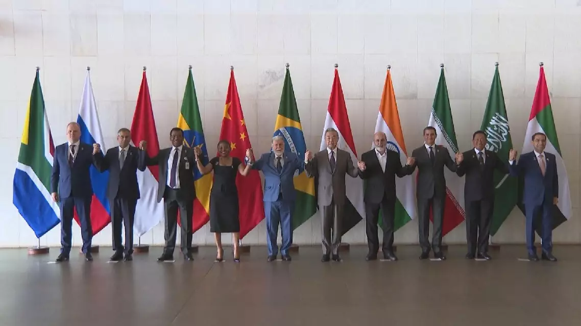
BRICS countries should become reliable force in safeguarding developing countries' rights: FM