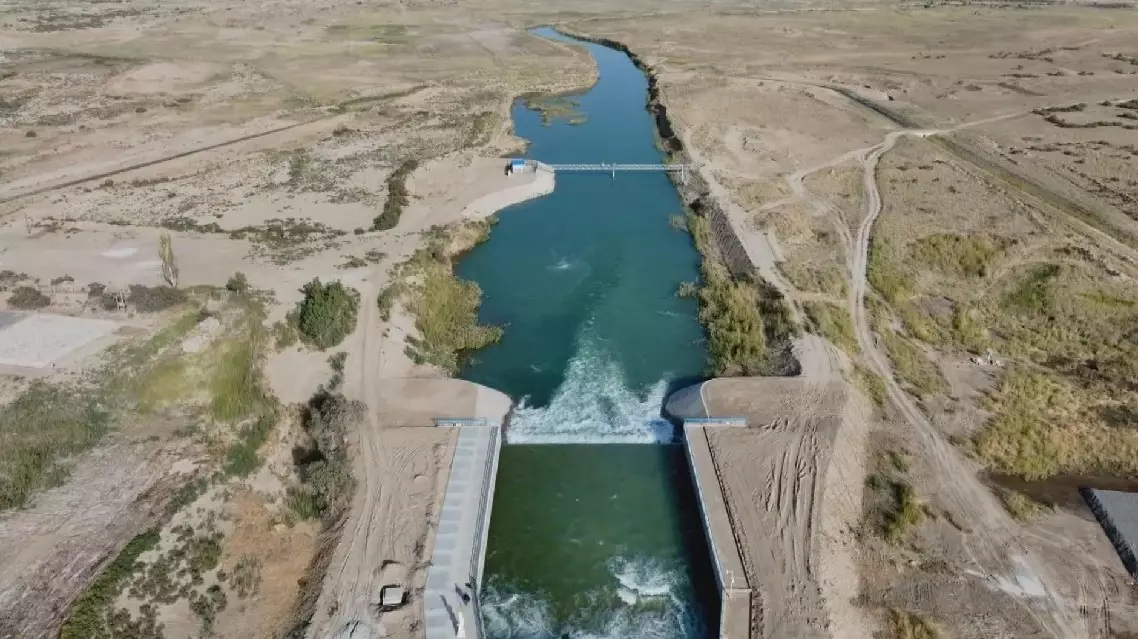
The Daxihaizi reservoir located in Yuli County, Bayingolin Mongol Autonomous Prefecture, northwest China's Xinjiang Uygur Autonomous Region, has reshaped its functions over the past 20 years to allow water to flow to the lower reaches of the Tarim River and thus played a vital role in ecological restoration in the region.
The Daxihaizi reservoir was built in the 1950s and 1960s and once played a crucial role in irrigating farmland along the lower reaches of the Tarim River.
Its location is quite unique, with the Taklimakan Desert to the south and the Kumtag Desert to the north. In its early days, the reservoir not only provided agricultural irrigation but also supported the surrounding forested areas.
In the mid-20th century, large-scale development and utilization of the upper and middle reaches of the Tarim River led to a sharp reduction in downstream water flow, often leaving the Daxihaizi reservoir without water to store.
The water that could be stored was prioritized for nearby agricultural irrigation.
Due to the limited farmland downstream, in the early 1970s, the Daxihaizi reservoir closed the gates that discharged water into the lower reaches of the Tarim River. As a result, the riverbed downstream for nearly 400 kilometers experienced a continuous dry spell for nearly three decades, leading to a catastrophic ecological decline.
During the nearly 30 years of cutoff flow in the lower reaches of the Tarim River, a series of ecological deterioration issues had occurred.
The large areas of vegetation and populus euphratica forests died off; and many sections of over 190 kilometers of the 218 National Highway were frequently buried by drifting sand; the Taitema Lake, located at the river's tail end, dried up; and the ecological corridor between the Taklimakan Desert and Kumtag Desert gradually disappeared.
"The encroachment of sand and the retreat of people became especially noticeable. In more concentrated residential areas, conditions were slightly better, but in sparsely populated areas, sand would pile up halfway up residents' doors As a result, those houses would be buried by the desert. So, everyone was feeling down. And when they looked at the uninhabited desert behind them, they could see what their own future might become," said Li Lijun, chief of Water Regulation Section, Tarim River Basin Mainstream Management Bureau.
A village in Ruoqiang County in the Bayingolin Mongolian Autonomous Prefecture, located 60 kilometers downstream from the Daxihaizi reservoir, was abandoned after the lower reaches of the Tarim River dried up.
In response to the worsening ecological crisis, people gradually recognized the need for more comprehensive and scientific management of the Tarim River.
Xinjiang then began implementing water-saving renovations in irrigation districts and reservoirs in plains, river channel management, and construction of regulatory water conservancy hubs in mountainous areas. These efforts aimed to regulate runoff, store water from wet seasons for use in dry periods, divert and store floodwaters, and conserve water.
In 2000, the Daxihaizi reservoir reopened its gates to release water downstream, ending nearly 30 years of flow cessation in the lower reaches of the Tarim River.
Starting in 2004, the Daxihaizi reservoir underwent functional adjustments and gradually phased out its role in the agricultural irrigation system.
The irrigation tasks previously handled by Daxihaizi are now shouldered by Qiala reservoir located 100 kilometers away.
Meanwhile, Daxihaizi became the only ecological reservoir in Xinjiang. Each year, in two stages, the floodwater stored during the flood season is used to carry out ecological replenishment in the lower reaches of the Tarim River.
"Over the past two decades, the Daxihaizi reservoir has released 10.2 billion cubic meters of ecological water, raising the groundwater level within a 1-kilometer range along both banks of the Tarim River's main channel from a pre-management depth of 8-12 meters to 2-4 meters. The water surface of the Taitema Lake has been maintained between 30 to 110 square kilometers, which is the optimal area for its ecological characteristics," said Li.

Daxihaizi reservoir reshaped functions, serves as vital role in ecological restoration


