The Qiantang River tidal bore is as famous as the ones on the Ganges in India and the Amazon in Brazil.
The river, originating in the border region of Anhui and Jiangxi provinces, runs for 459 kilometers through the coastal Zhejiang province, passing through the provincial capital Hangzhou before flowing into the East China Sea via the Hangzhou Bay.
Click to Gallery
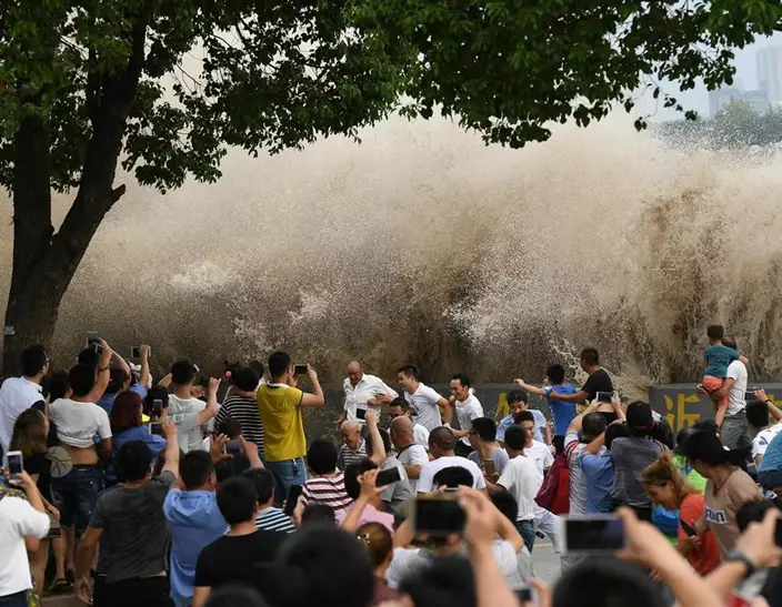
The annual Qiantang River tidal bore, which is expected to be seen this year during the National Day holiday week, attracts tens of thousands of people from home and abroad. (Photo/China Daily)
Thousands of people gather on the bank of the Qiantang River last year to get a view of the annual tidal bore in Hangzhou, Zhejiang province. (Photo/China Daily)
The annual Qiantang River tidal bore, which is expected to be seen this year during the National Day holiday week, attracts tens of thousands of people from home and abroad. (Photo/China Daily)
The two tides then come closer and flow together like embracing lovers, offering a magnificent view. (Photo/China Daily)
The river is the southern terminus of the ancient Grand Canal that links five major rivers in China from north to south, and enables water-borne traffic to travel inland from Hangzhou as far north as Beijing.
While the Hangzhou Bay at the mouth of the Qiantang is about 100 km wide, the river narrows to a mere 2-3 km at one point-its Yanguan section. And as the tidal waters are blocked by the narrow river passage, pressure builds up from behind until a tidal bore is formed, creating a high water wall.
The annual Qiantang River tidal bore, which is expected to be seen this year during the National Day holiday week, attracts tens of thousands of people from home and abroad. (Photo/China Daily)
In addition, the presence of a submerged sandbar at the mouth of the river acts like a springboard for the tide, sending the crest of the bore higher.
Also, combined with the gravitational pull of the celestial bodies and the centrifugal force produced by the rotation of the Earth, tidal waves are created for the first five days and in the middle of every month according to the lunar calendar, which adds up to about 120 days a year.
Around the middle of the eighth month this year, based on the lunar calendar, the tidal force reached its peak, and the waves were as high as 5 meters, with a tidal range of up to 10 meters between the highest and the lowest points.
However, the most extraordinary sight can be expected from Oct 4 to 7 during the country's yearly National Day holiday week.
The Qiantang tide has been well documented since ancient times.
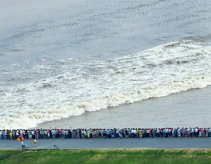
Thousands of people gather on the bank of the Qiantang River last year to get a view of the annual tidal bore in Hangzhou, Zhejiang province. (Photo/China Daily)
As early as the 4th century BC, China's famous philosopher Chuang Tzu (Zhuang Zi) described the huge tide as follows: "The waters in the Qiantang River will roll on, raising waves as high as mountains and towers, creating a thunderous roar and gathering up a force that threatens to engulf the sun and the sky."
A famous poet Su Dongpo in Northern Song Dynasty (960-1127) wrote:
"What on Earth can hope to create a spectacular sight,
Like the tides on the eighteenth of August at night."
Tide watching on the Qiantang has been a popular activity for centuries, dating back to the Han Dynasty (206BC-AD220).
It had also become a well-established event on the social calendar for both ordinary people and the royal court by the time of the Southern Song Dynasty (1127-1279).
The annual Qiantang River tidal bore, which is expected to be seen this year during the National Day holiday week, attracts tens of thousands of people from home and abroad. (Photo/China Daily)
The Southern Song government even made it a rule to parade its naval forces in the Qiantang River on the 18th day of the eighth lunar month, an event that later developed into the present tide watching festival.
During the festival, expert swimmers line up to test their valor against the might of the tide each year.
There are historical records of men who would attempt to ride the waves of the tide on specially constructed boards.
Known in Chinese as nong chao er or "tide player", they are regarded as the first generation of Chinese surfers.
It is a tribute to their daring and skill that the words nong chao er have now come to mean people who are brave and courageous in the face of adversity.
In the Song Dynasty (960-1279), the best site to watch the tide bore was the 5-km stretch of riverbank that now lies between Miaozitou and Six Harmonies Pagoda.
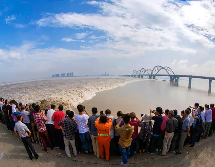
The annual Qiantang River tidal bore, which is expected to be seen this year during the National Day holiday week, attracts tens of thousands of people from home and abroad. (Photo/China Daily)
With the passage of time, however, the best spot to get a view of the tidal bore has now shifted to a section of the seawall in Yanguan township in Haining county.
Now, in the small town of Yanguan, about 40 km away from Hangzhou, the Qiantang River Tide Watching Festival is held annually, attracting tens of thousands of people from home and abroad.
Besides the magnificent tidal bore, people can observe other bores-the one-line bore, the cross bore and the back-flow bore.
Yanguan town, where the grand festival is held, offers the best view of the one-line bore. There, the water runs like a line of troops marching forward at a steady pace amid a thunderous sound.
The cross bore is rare and can be seen clearly only from the Jiaxing-Shaoxing bridge in Hangzhou Bay.
There, the Qiantang River tide divides into two strands to pass the sediment accumulation in the bay area.
The annual Qiantang River tidal bore, which is expected to be seen this year during the National Day holiday week, attracts tens of thousands of people from home and abroad. (Photo/China Daily)
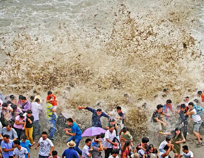
The back-flow bore is the most popular one with young people where they wait at the river dike.
When the waters come toward them, the cautious ones move away, but many wait until the 5-meter high water wall crashes into the dike.
The back-flow bore can be experienced at Laoyancang in Haining county, in Jiaxing city, as well as in Qige, in Jianggan district and at the Beauty dike, in Xiaoshan district in Hangzhou.
Be sure to arrive at the place of your choice in time, or you may miss the short but breathtaking spectacle that can be seen only once a year.
The two tides then come closer and flow together like embracing lovers, offering a magnificent view. (Photo/China Daily)
PORTLAND, Maine (AP) — The U.S. East Coast began a whiplash-inducing stretch of weather Wednesday with a deluge of rain, rapid snowmelt and powerful gusts, creating dangerous conditions, due in part to an atmospheric river and developing bomb cyclone.
Ski resort operators in the Northeast watched their snow turn to mush with a deluge of rain and unseasonably high temperatures — followed by damaging winds — all in the same day, part of a powerful storm system that stretched from Florida to Maine.
Utilities braced for widespread power outages with winds projected to exceed 60 mph (97 kph) through late Wednesday. Isolated severe thunderstorms were possible southward into portions of Florida. Elsewhere, heavy lake effect snow was expected through Thursday in parts of Michigan, along the Lake Michigan shoreline, and dangerous cold enveloped parts of the Upper Midwest.
A key driver in the weather was an atmospheric river, which is a long band of water vapor that can transport moisture from the tropics to more northern areas, said Derek Schroeter, a forecaster with the National Weather Service. New England was bearing the brunt as the storm tapped moisture from the Atlantic Ocean off the coast of the U.S. Southeast, and transported it to places like Maine, he said.
Forecasters also said the storm had the potential to include a process that meteorologists call bombogenesis, or a “bomb cyclone.” That’s a rapid intensification of a cyclone in a short period of time, and it has the ability to bring severe rainfall.
“Is that what they’re calling it?” said Jen Roberts, co-owner of Onion River Outdoors sporting goods store in Montpelier, Vermont. She lamented that a five-day stretch of snowfall that lured ski customers into the store was being washed way, underscoring the region’s fickle weather. “But you know, this is New England. We know this is what happens.”
Alex Hobbs, a Boston college student, hopes that the weather won’t interfere with her plans to return home to San Francisco soon.
“I’m a little worried about getting delays with heavy wind and rain, possibly snow,” she said Wednesday.
In New England, the storm began with combination of fog and freezing rain Tuesday night into early Wednesday, making travel treacherous. A tractor-trailer carrying a load of oranges went off the Maine Turnpike in New Gloucester; the road was so treacherous that the oranges couldn’t be removed until a day later.
In New Hampshire, the Mount Washington Avalanche Center issued a special bulletin Wednesday for the Presidential Range of mountains, which received significant snowfall over the last two weeks. “Heavy rainfall could create dangerous and unpredictable avalanche conditions on steep snow-covered slopes,” the avalanche center warned.
Atop Mount Washington, wind gusts hit 89 mph (143 kph). The location is one of the planet’s windiest spots. Its highest gust recorded for 2023 was 132 mph (212 kph). From January to December of that year, it saw 145 days with gusts of 73 mph (117 kph) or higher.
The rain should help ease drought conditions in the region. As recently as last week, state environmental officials in Massachusetts raised drought concerns on Cape Cod, while a more critical drought declaration remained in effect in other parts of the state.
Flood watches were in effect in Vermont, where the capital city of Montpelier, hard hit in past floods, advised residents to elevate items in basements and low areas that are prone to flooding. And in Rhode Island, heavy surf and flooding closed several roads in Newport.
There were power outages scattered across the region. In Rhode Island more than 6,000 were without power at about 6 p.m., compared to 4,900 in Massachusetts and 4,300 in Maine.
In Higganum, Connecticut, 13 students and a bus driver had to wait inside their bus as utility crews and firefighters removed downed electrical wires that fell onto the bus. Once the area was deemed safe, students evacuated the bus and boarded another that took them to their parents, said Olivia Drake, public information officer for the Haddam Volunteer Fire Company.
It was the fire department’s third incident involving power lines on Wednesday. Earlier in the day, firefighters responded to a pole fire and a tree that was leaning on power lines and was smoldering.
Ski resorts around the Northeast were preparing visitors for a potentially messy day on Wednesday. “We don’t say the ‘r-word’ around here. It’s a forbidden word,” said Jamie Cobbett, marketing director at Waterville Valley Resort in New Hampshire. “We’re getting some moist wet weather today. We’ll put the mountain back together tonight, and hopefully we’ll be back skiing tomorrow with no problems.
At Vermont’s Sugarbush resort, skier Marcus Caston was waterlogged but shrugged it off. “The conditions are actually pretty good. The rain is making the snow nice and soft. It’s super fun,” he said. “We’re having fun out here.”
Associated Press writers Lisa Rathke in Marshfield, Vermont, Michael Casey and Steve LeBlanc in Boston, Susan Haigh in Norwich, Connecticut and Kathy McCormack in Concord, New Hampshire, contributed to this story.
Rain water from a winter storm flows through the empty parking lot near the Panorama lift at the Gunstock Mountain Resort ski area , Wednesday, Dec. 11, 2024, in Gilford, N.H. (AP Photo/Charles Krupa)
A man walks a dog as light rain falls during a winter storm, Wednesday, Dec. 11, 2024, in Concord, N.H. (AP Photo/Charles Krupa)
This Dec. 11. 2024 image provided by the National Oceanic and Atmospheric Administration (NOAA), shows a storm passing through the U.S. Atlantic east coast. (NOAA via AP)
Ducks stand on the rain water covered ice on Adams Pond during a winter storm, Wednesday, Dec. 11, 2024, in Derry, N.H. (AP Photo/Charles Krupa)
A construction worker is bundled up in winter clothes while installing weather sheathing on a building during a rain storm, Wednesday, Dec. 11, 2024, in Derry, N.H. (AP Photo/Charles Krupa)
A tractor-trailer hauling a load of oranges sits on the side of the road after sliding off the Maine Turnpike early on Wednesday, Dec. 11, 2024, in New Gloucester, Maine. (AP Photo/David Sharp)
Rain and snow falls near the Presumpscot River in Falmouth, Maine as officials are watching for flooding on New England rivers, Wednesday, Dec. 11, 2024. (AP Photo/Patrick Whittle)
Passengers disembark from a ferry in a steady downpour of rain in Boston’s Seaport neighborhood on Wednesday Dec. 11, 2024. (AP Photo/Michael Casey)
A jogger runs along the harbor as rain falls in Boston’s Seaport neighborhood on Wednesday Dec 11, 2024. (AP Photo/Michael Casey)
A few boats move through the fog that had descended on the harbor in Boston on Wednesday, Dec. 11, 2024. (AP Photo/Michael Casey)
A person walks through the rain as a storm system and possible "bomb cyclone" hit the U.S. East Coast, Wednesday, Dec. 11, 2024 in Portsmouth, N.H. (AP Photo/Caleb Jones)
People walk through the rain as a storm system and possible "bomb cyclone" hit the U.S. East Coast, Wednesday, Dec. 11, 2024 in Portsmouth, N.H. (AP Photo/Caleb Jones)
People walk to their cars as freezing rain and snow falls in Kennebunk, Maine on Wednesday, Dec. 11, 2024. (AP Photo/Patrick Whittle)
FILE - Tristan Millstone reacts as he steps in water after kayaking across a flooded section of Neely Road to buy groceries after a major storm in Guerneville, Calif., Saturday, Nov. 23, 2024. (Stephen Lam/San Francisco Chronicle via AP, file)